Ask an expert: A newly identified aquifer could provide water supply for Texas Posted on April 11, 2022
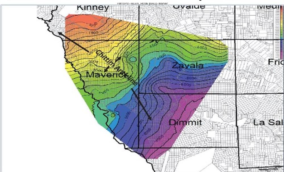
In an area of the state known for its desert landscape and dry environment, scientists and groundwater experts are mapping and evaluating a potential new underground water source. The Groundwater Advisory Unit of the Railroad Commission of Texas announced in 2021 the identification of the Maverick Basin aquifer, which is located thousands of feet deep in the Glen Rose Formation and has been tentatively mapped in Maverick, Zavala, Dimmit, Kinney, and Uvalde counties.
The Texas Water Development Board (TWDB) Brackish Resources Aquifer Characterization System (BRACS) Team and Groundwater Technical Assistance Team are involved in assessing the aquifer. Natalie Ballew, Manager of Groundwater Technical Assistance, shared some background on the aquifer, which has the potential to contribute much-needed water supply to the area.
When and how was the aquifer discovered?
The Railroad Commission’s (RRC’s) Groundwater Advisory Unit announced the identification of the aquifer in November 2021. The agency’s research into the aquifer began after a driller sought permission to convert an oil well into a drinking water well. This process resulted in the RRC’s identification of the aquifer’s production of a large quantity of freshwater, which is surprising given the depth is over a mile below the land surface in the deepest locations. The RRC shared the aquifer’s identification with the TWDB and encouraged studies on the aquifer’s characteristics and research on the possibility of designating the formation as an official aquifer.
What research is being conducted on the aquifer?
In addition to other studies, the teams from the University of Texas and Texas A&M University are conducting water quality studies to find out where the water is coming from and how the aquifer recharges. One leading theory is that the Maverick Basin aquifer is recharged by precipitation onto the outcrop (where the formation is exposed on the land surface) in Mexico.
The TWDB BRACS Team is currently analyzing data on the Maverick Basin aquifer as part of a regional Edwards-Trinity (Plateau) Aquifer brackish groundwater study. Once we have a better understanding of the quantity and quality of water in the formation, TWDB staff members will begin the process of gathering data to evaluate water supply needs and future demands on the aquifer. Ultimately, research will help determine if the aquifer can be classified as an official aquifer. If the Maverick Basin aquifer is classified as an official aquifer, the TWDB will work to create a groundwater availability model as a resource for regional water planning efforts.
In contrast to the initial studies on the last officially designated aquifer, Cross Timbers Aquifer, which took about a year to complete, research on the deeper Maverick Basin aquifer will likely take several years. Part of the reason initial research will take more time is that there are fewer wells in this region than in the Cross Timbers Aquifer region to provide data about the water underground.
How could the research findings impact communities?
If the Maverick Basin aquifer is found to be a useable freshwater resource, it could be another water supply option for communities in that area. With the assistance of landowners and funding, it is possible that existing oil and gas wells in the aquifer’s area could be converted to public water supply wells. In addition, if the aquifer receives an official aquifer designation, long-term water use plans for the aquifer could be established, helping to ensure it is managed sustainably.
How will the name of this aquifer be selected?
Unofficially, the new aquifer has been called the “Maverick aquifer” due to its location in the Maverick Basin of Maverick County, but it is also referred to as the “Deep Glen Rose Formation in South Texas” because the aquifer is part of that geological formation. Another name used is the "Maverick Basin aquifer." If designated as an official aquifer, the TWDB Groundwater Technical Assistance Department will coordinate the naming process. In the past, aquifer names have reflected their geographic region or the aquifer’s characteristics and features.
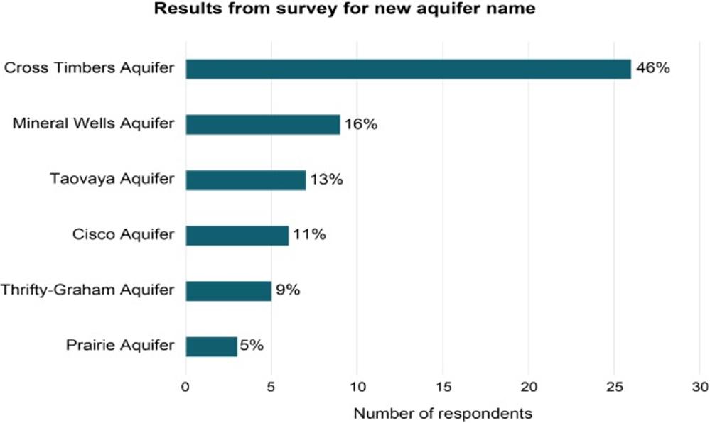
For example, the Cross Timbers Aquifer in north central Texas was designated a minor aquifer by the TWDB after the agency identified several possible names for the aquifer. The TWDB hosted a public survey, and "Cross Timbers Aquifer" was the most popular.
About Natalie Ballew
As the TWDB’s Manager of Groundwater Technical Assistance, Natalie Ballew oversees technical data on the state’s groundwater. In her role, Natalie provides guidance to groundwater conservation districts on technical modeling results, groundwater data, interpreting agency rules, and procedural tasks. Natalie and her team also conduct groundwater research projects in cooperation with groundwater districts and other agencies. She is a licensed Texas professional geoscientist and holds a master of science in energy and earth resources and a master of public affairs in water resource management from the University of Texas.
What we currently know
- Aquifer type: confined transborder aquifer with artesian flow
- Formation: Upper Glen Rose Formation, Trinity Group
- Depth: greater than 5,000 feet
- Area of the aquifer in Texas: at least 3,000 square miles
- Recharge zone: believed to be 50 miles west of the Rio Grande in Mexico
This article is posted in .