What to know about the Texas drought Posted on September 14, 2022
What to know about the Texas drought
Last month, Texas finally got some much-needed relief from an extremely hot and dry summer. In August, record-breaking rainfall significantly improved drought conditions in parts of the state. And more rain and below-normal temperatures are expected through at least the end of September. Despite lower temperatures and increased precipitation that have helped ease the drought, we haven’t crossed the finish line just yet.
The current drought situation didn’t develop overnight.
Unlike flash floods or tornadoes, droughts are slow-moving threats. Pinpointing the beginning of a drought can be challenging, but decreased rainfall and reduced soil moisture are early indicators. As drought continues and expands, reduced streamflow and decreasing water levels in reservoirs signal drier-than-normal conditions.
The current Texas drought began in September 2021, spurred by a La Niña climate pattern that resulted in drier and hotter conditions across the southern United States, which persisted through the end of 2021 and ended with the hottest Texas December on record.
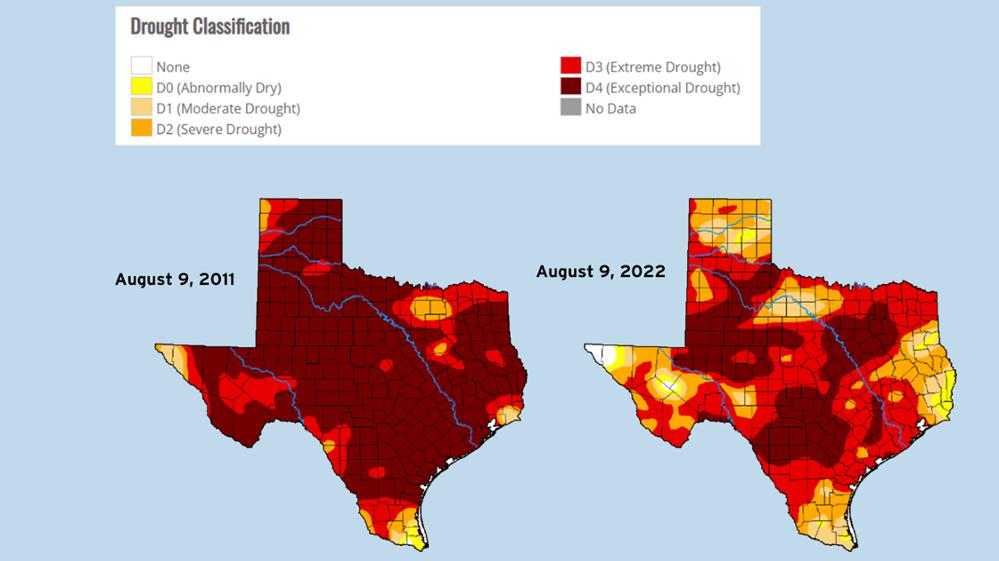
April through July 2022 was the hottest stretch on record for those months in Texas. In addition, triple-digit temperatures and below-normal rainfall over the last few months intensified drought conditions by drying out soils and increasing evaporation from water bodies and the landscape. By early August, drought had intensified across most of Texas, covering a large swath from North Texas to South Texas. At that point, rainfall deficits in much of Central Texas and southeastern Texas were between 11 and 16 inches.
While the present drought has been destructive, it’s not the worst drought on record.
The drought of the 1950s—which lasted from 1949 through 1957—is the worst statewide drought in Texas’ history (dating back to 1895) in terms of duration and intensity. It is widely considered the statewide drought of record and serves as the basis for state water planning in Texas.
During the 2010–2014 drought, there were weeks when drought impacted 100 percent of the state, and 2011 was the driest 12 consecutive months statewide on record.
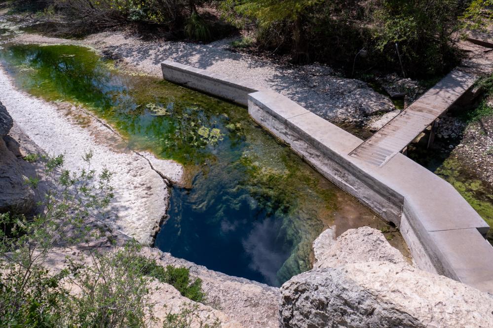
But looking at a drought’s consequences from a broader perspective doesn’t capture the localized impacts. Regionally, some areas of Texas have fared worse than in 2011. For example, Midland had its driest period since 2011 from September 2021 through May 2022. In Central Texas, Jacob’s Well stopped flowing for the fifth time in recorded history because there hasn’t been enough rainfall to recharge the Trinity Aquifer, which supplies the springs.

Rainfall doesn’t equal a get-out-of-jail-free card.
While all rain is beneficial, a single rainstorm isn’t enough to alleviate drought. Deep soaking and multiple rain events over several months are typically needed to reach lower levels of the soil and to break a drought. But rainfall isn’t the only factor involved in a drought’s demise—cooler temperatures can reduce the evaporation of water from the soil and surface water reservoirs.
The end of a drought also depends on the type of drought being experienced. For example, meteorological droughts can begin rapidly and end when dry weather patterns no longer dominate an area. In contrast, hydrological droughts take longer to develop and conclude when the streams, reservoirs, and groundwater levels reach normal or above-normal conditions.
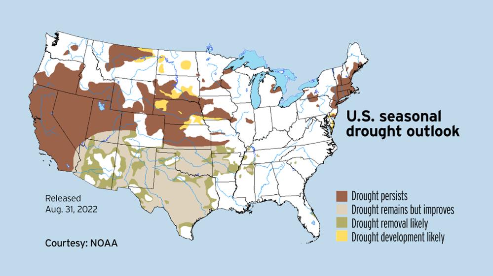
How long will the current drought last? A return to average rainfall conditions in September and October could provide much-needed relief. And, while the current hurricane season has been quiet here in Texas, we could still see tropical activity through the end of November. But the La Niña climate pattern that has contributed to drier and hotter-than-average conditions since late 2021 is anticipated to continue into early 2023, suggesting that drought is likely to remain in many areas of the state.

The Texas Water Development Board is a wealth of resources.
Planning for and responding to drought happens at the local, regional, and state level. Among other efforts, local planners prepare drought contingency plans, regional groups create regional water plans, and the Texas Water Development Board (TWDB) produces the state water plan based on the regional plans.
The regional planning process considers a 50-year horizon, and each region plans using the most relevant, localized drought of record—generally by river basin. The advantage of Texas’ planning process is that each planning cycle intentionally considers new information, including data related to recent droughts.
In addition to the water planning process, the TWDB provides a variety of resources to assist Texans with drought response and preparedness:
-
Interactive Drought Dashboard – provides weekly drought data and monthly rainfall and temperature data at the county and watershed level, monthly streamflow data at the watershed level, and daily soil moisture data at the county level
-
Water Weekly – summarizes drought conditions across the state
-
Texas Water Conditions Report – a monthly summarization of drought and water conditions across the state
-
Urgent need funding through the Drinking Water State Revolving Fund – assists communities with addressing unforeseen situations that require immediate attention to protect public health and safety
-
Outreach – technical assistance, educational materials, and literature
Every drop counts.
Our finite water supplies must be managed wisely, which means everyone must do their part to conserve water. Every Texan can do simple things to make a difference, and every little bit counts when it comes to water conservation. Check out the TWDB’s website for some outdoor and indoor water-wise tips you can implement right now to help ensure no drop of water is wasted.
While the term drought has many definitions, there are several common descriptions of drought, including meteorological, agricultural, hydrological, and socioeconomic.
-
Meteorological drought begins with a period of abnormally dry weather resulting in less than the long-term average rainfall for that period. It does not necessarily impact water supply.
-
Agricultural drought often follows or coincides with meteorological drought and can appear suddenly and cause rapid impacts to agriculture. It reduces soil moisture, which decreases crop or range production and increases irrigation demands. It often leads to drought disaster declarations and, in many cases, is an indicator of an impending hydrological drought.
-
Hydrological drought is a period of below-average streamflow and water volume in aquifers and reservoirs, resulting in reduced water supplies. It is the focus of regional water planning because it impacts water supplies.
-
Socioeconomic drought occurs when physical water needs affect the health, safety, and quality of life of the general public or when the drought affects the supply and demand of an economic product.
The U.S. Drought Monitor map is released every Thursday and shows areas of the United States that are in drought. The weekly drought conditions map uses five classifications: abnormally dry (D0), showing areas that may be going into or are coming out of drought, and four levels of drought: moderate (D1), severe (D2), extreme (D3) and exceptional (D4). Variable factors like rainfall, soil moisture, and temperature are considered when determining a drought stage.
Has your city or public water system implemented restrictions?
This article is posted in Aquifers / Springs / Drought / Groundwater / Conservation .
